Natural Resource Management (NRM) refers to the sustainable management/utilization of major natural resources, such as soils, water, flora and fauna etc. Together, these resources provide the ecosystem services that provide better quality to human life. Natural resources provide fundamental life support, in the form of both consumptive and public-good services. Proving ecological processes to maintain soil productivity, nutrient recycling, the cleansing of air and water, and climatic cycles.
To manage your natural resources locally you have to know what they are and manage according to your land-use and those around you.
To manage your natural resources locally you have to know what they are and manage according to your land-use and those around you.
The following information is a brief introduction into the catchments average rainfall, groundwater and soil types though these vary considerably depending on your location. Our catchments other natural resources are discussed under our catchments assets
Rainfall
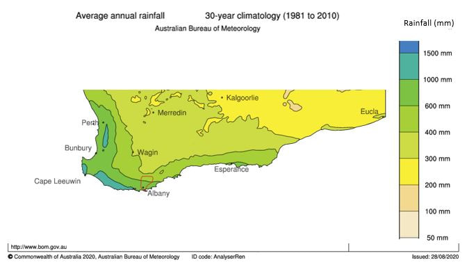
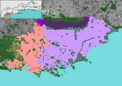
Rainfall varies greatly between the southern and northern parts of the catchment with an annual average of around 950mm closer to the coast, compared to 450mm in the north. Soil types also vary from north to south. The northern and central areas of the catchment are dominated by tertiary sediments over granitic bedrock and the terrain is undulating with low lying stagnant flats. Whilst in the southern parts the soils are derived from granitic material and the landscape is more dissected.
Soils
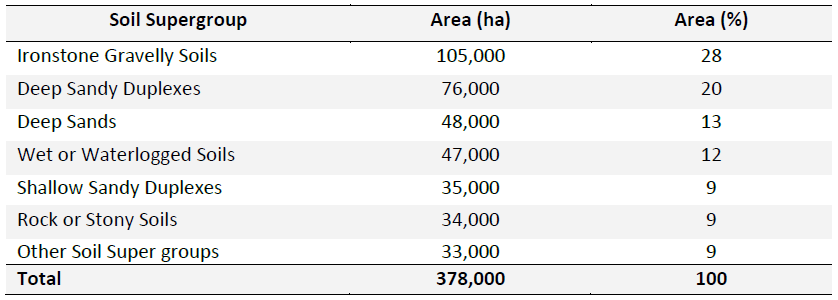
The most common soil supergroup in the Oyster Harbour Catchment is the ironstone gravelly soils representing 28 percent of this area, followed by deep sandy duplexes (20 percent), deep sands (13 percent) and wet or waterlogged soils (12 percent).
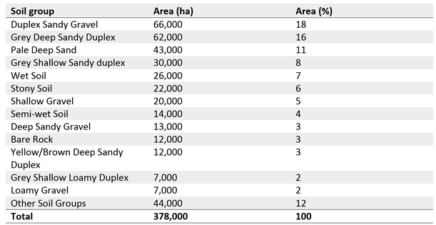
Soil groups are defined within soil super groups and are used to identify the soil component of the land resource datasets maintained by the Department of Primary Industries and Regional Development. Duplex sandy gravel, grey deep sandy duplex and pale deep sandy soils are the most common soil groups in this area, together covering 44 per cent of the Oyster Harbour Catchment (Table 2). All other soils were found in less than 9 per cent.
Major soil degradation hazards in this area include subsurface soil compaction, water repellence, soil acidity, water erosion and wind erosion.
To examine the health of your soil in particular, compare your data and examine soil relationships we recommend using tools provided on www.soilquality.org.au/. As it covers the soils biological, chemical and physical properties that promote the health of plants, animals and humans while also maintaining environmental quality.
Groundwater
Water that has travelled down from the soil surface and collected in the spaces between sediments and the cracks within rock is called groundwater. Groundwater fills in all the empty spaces underground, in what is called the saturated zone, until it reaches an impenetrable layer of rock. Groundwater is contained and flows through bodies of rock and sediment called aquifers. The amount of time that groundwater remains in aquifers is called its residence time, which can vary widely, from a few days or weeks to 10 thousand years or more. Groundwater is everywhere beneath the soil surface and can be ever-present in many places if allowed to recharge. Even in dry conditions, it maintains the flow of rivers and streams by replenishing them, providing a valuable substitute for precipitation.
Groundwater flow systems are local and roughly align with the direction of surface drainage. The more dissected areas have a high groundwater gradient, which allows groundwater to move towards low-lying discharge areas such as creeks and valley floors. Shallow bedrock can partially obstruct groundwater flow and causes hillside seeps in this region.
Oyster Harbour Catchment aligns with the Albany Sandplain Central Zone. This covers one-third of the Albany Hinterland sub-region on the South Coast. It is bounded by the Stirling Ranges to the north, the Pallinup River to the east, the Kalgan River catchment divide to the west and the Southern Ocean in the south.
It contains broad plains with numerous lakes and seasonally inundated depressions. The sandplain has poor internal drainage. Linear sand dunes and lunettes adjacent to swamps are common. Some of the deeper lakes are saline. Closer to the coast, small rivers improve drainage.
The Groundwater flow systems lie beneath the sandplain is an intermediate to regional saline system with very low gradients (<0.5%) resulting in very little lateral flow.
Groundwater discharge does occur in some places in areas where lakes intercept groundwater; however the effect of this discharge is minimal. The smaller rivers close to the coast have local to intermediate groundwater systems and discharge into the Southern Ocean.
Groundwater depth, in the sandplain area ranges from 7 m to more than 20 m, while areas that drain into creeks have water within 5 m of the surface.
The sandplain has a medium risk of shallow watertables due to current depth and rate of rise. At the current rate, it will be more than 50 years before groundwater is close to the surface. Low-lying areas where groundwater has risen and intercepted the surface will create discharge areas (usually lakes). The number of these areas will increase and more low-lying areas will become affected by salinity as groundwater levels rise.
Salinity, Inundation and Water-logging
Salinity, inundation and water logging affects discharge zones and their fringes, where groundwater is <1.5m from the soil surface. Salinity issues are caused by recharge in the nearby areas. Groundwater salinity ranges from 300 mS/m (brackish) to 3,300 mS/m (saline). Groundwater pH is 6 to 7 (neutral). Levels are currently rising at a steady rate of 0.10–0.15 m/yr (Figure 1: bores Koj1d88 and SH1d90).
The recovery of salt-affected land has a low technical feasibility because it would require a significant reduction in recharge over a large area to impact on the regional aquifer. However with current management practices it is possible to adapt to salinity. Additionally, with the relatively deep groundwater, there is time to plan and implement containment strategies. Treatment of recharge zones in this area will have a quick effect on salinity of landscape and groundwater levels will start to drop a few years after treatments. Growing perennial pastures are the best option in the Oyster Harbour Catchment area. See Saltland Genie for the latest information on profitable saltland solutions for your property.
The recovery of salt-affected land has a low technical feasibility because it would require a significant reduction in recharge over a large area to impact on the regional aquifer. However with current management practices it is possible to adapt to salinity. Additionally, with the relatively deep groundwater, there is time to plan and implement containment strategies. Treatment of recharge zones in this area will have a quick effect on salinity of landscape and groundwater levels will start to drop a few years after treatments. Growing perennial pastures are the best option in the Oyster Harbour Catchment area. See Saltland Genie for the latest information on profitable saltland solutions for your property.
Further information found in our office library
|
Engage with us online by liking and following us on social media
|
|
We acknowledge the Minang and Koreng people as the traditional custodians of the land on which we work and live. We pay our respects to the Elders, past, present, and emerging and to the wider Noongar community.
Sponsors and Supporters

|

|

|


|